
Older Buildings in the Ferry Pier Area
This page brings together all the large scale maps of the ferry pier area. The maps show the area from 1845 to 1966.
The railway plans were created to show the properties which the railway companies intended to purchase before the construction of a railway line. The 'limits of deviation' were the boundaries of the land proposed to be acquired, allowing for a flexibility in the actual location of the railway line. The companies were not interested in any properties outside these limits, which is why some buildings are shown without accompanying details on the plans. It was basically intended compulsory purchase.
For the Tay Ferry plans, the properties were those proposed to be acquired for the management of the ferry (1869), or to be taken back by the Harbour Trustees (1872) for their ownership.
1845 Edinburgh & Northern Railway
Original at National Records of Scotland, ref. RHP85261
More information on the railway proposals here
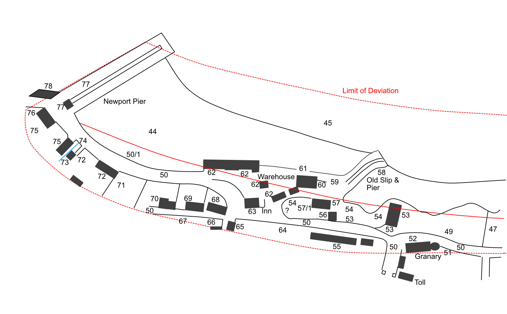
| Ref | Description | Owner or reputed owner | Occupier | [Comments] | Location |
|---|---|---|---|---|---|
| 36 | Arable land | John Rogers | Mrs Elizabeth Rogers | ||
| 37 | Sea braes & trees | John Rogers | Mrs Elizabeth Rogers | ||
| 38 | Salmon fishings | William Berry | Alexander Harris | ||
| 39 | Occupation road | James Wilson | The owner, William Berry, the Public | ||
| 40 | Arable land | James Wilson | James Wilson | ||
| 41 | Private road | James Wilson | James Wilson | ||
| 42 | Dwelling houses, outhouse & garden ground | James Wilson | James Wilson | ||
| 43 | Occupation or servitude footpath | William Berry, James Wilson | The Public | ||
| 44 | Ground covered by high water | The Crown, or the Lords of the Admiralty, or William Berry, James Wilson, the Scottish Central Railway Co & John Rogers | The Owners and the Public | ||
| 45 | Ground under low water | The Crown, or the Lords of the Admiralty, or William Berry, James Wilson, the Scottish Central Railway Co | The Owners and the Public | ||
| 46 | Dwelling houses, outhouses, garden ground, pasture ground, sea braes & private road | William Berry | James Wilson (lessee & occupier), John Harris (occupier) | [not shown. Kempstane] | Location Location 2 |
| 47 | Bleaching green, pasture ground, sea braes or common, 2 wells, bathing house & rocks | William Berry | The Owner, William Turnbull, James Wilson, John Harris and the Public | [Ran from the foot of William St to just past the foot of James St] | |
| 48 | Salmon fishings | William Berry | Alexander Harris | [not shown] | |
| 49 | Pasture ground and sea braes | William Berry | Mrs Anne Brand | ||
| 50 | Turnpike road | Trustees of Turnpike Roads, St Andrews District | William Stobie, tacksman of tolls (lessee); the Public (occupiers) | ||
| 50/1 | Sea wall | Trustees of Turnpike Roads, St Andrews District or Trustees of Tay Ferries, or Scottish Central Railway Co | |||
| 51 | Stackyard | William Berry | Charles Mitchell (lessee & occupier) | Location | |
| 52 | Mill shed, stables, outhouses and court | William Berry | Charles Mitchell (lessee & occupier) | [On the corner of Tay St and Cupar Rd] | Location |
| 53 | Granary and private roads | William Berry (superior); James Wilson (proprietor) | James Wilson & John Aymer | [Opposite the bottom of the Cupar Rd] | Location Location 2 |
| 54 | Braes & pasture | William Berry | Mrs Anne Brand | ||
| 55 | Dwelling houses & garden ground | William Berry | William Turnbull, John Bell, Alexander Milne, Alexander Harris, Mrs Menzies Mackie, John Kidd, Thomas Pinn & Mrs Catherine Brown | [At the top of the High St] | Location Location 2 Location 3 |
| 56 | Old lock-up house | William Berry | Unoccupied | Location | |
| 57 | Stable | William Berry | Michael Smith | Location | |
| 57/1 | Coal shed | William Berry | David Spence | Location | |
| 58 | Old pier | William Berry | The Public | [Old Pier] | |
| 59 | Occupation or servitude road, pier-head and ground | William Berry | The Public | ||
| 60 | Granaries | William Berry | James Bogie, James Lindsay, & part unoccupied | Location Location 2 | |
| 61 | Sea wall | William Berry | |||
| 62 | Stables, coach houses, sheds, cellars, areas, or vacant ground, stable-yard, court & private road | William Berry | Charles Mitchell (lessee & occupier) | [part of Newport Hotel] | Location |
| 63 | Dwelling house, outhouses and water cistern | William Berry | Charles Mitchell (lessee & occupier) | [Newport Hotel] | Location |
| 64 | Garden ground | William Berry | Charles Mitchell (lessee & occupier) | [Bottom half of the High St; ground let with Newport Hotel] | |
| 65 | Dwelling house, garden & private road | William Berry | Mrs Anne Brand | [4/6 High St] | Location |
| 66 | Dwelling house | William Berry | Mrs Margaret Foreman or Henderson, and part unoccupied | [Demolished, site of shed at 4/6 High St] | Location |
| 67 | Arable ground | William Berry | William Berry | ||
| 68 | Dwelling house, garden and area | William Berry | Mrs Margaret Foreman or Henderson, and Charles Mitchell | [Old St David's Inn, site of Trinity Church] | Location Location 2 |
| 69 | Dwelling house & gardens | William Berry | Margaret Meldrum, John Duncan, Alexander Moir and Thomas Clark | Location Location 2 Location 3 | |
| 70 | Dwelling house, garden, private road & well | William Berry | James Smith | [Chapel House] | Location Location 2 |
| 71 | Garden ground | William Berry | John Just (lessee & occupier) | [Seamills] | |
| 72 | Dwelling house, kiln, shed, outhouses, courts, ground & private roads | William Berry | John Just (lessee & occupier) | [Seamills] | Location |
| 73 | Barley mill, meal mill, area & private road | William Berry | John Just (lessee & occupier) | [Seamills] | Location |
| 74 | Mill lade & mill race | William Berry | John Just (lessee & occupier) | [Seamills] | |
| 75 | Warehouse, granary, ground & shed | William Berry | Mrs Anne Brand (lessee & occupier), the Scottish Central Railway Co (occupier), & part unoccupied | Location | |
| 76 | Dwelling house | William Berry | Charles Mitchell (lessee & occupier) | ||
| 77 | Passage pier & shed | Trustees of the Tay Ferries; or the Scottish Central Railway Co | The Owners & the Public | [Ferry Pier] | Location |
| 78 | Coal sheds | Trustees of the Tay Ferries; or the Scottish Central Railway Co | The Owners |
1845 Glasgow & Dundee Junction Railway
Original at National Records of Scotland, ref. RHP85254
More information on the railway proposals here
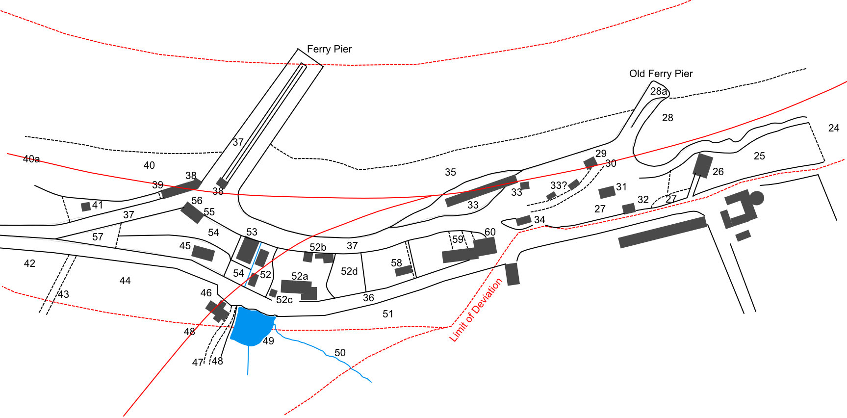
| Ref | Description | Owner or reputed owner | Occupier | [Comments] | Location |
|---|---|---|---|---|---|
| 25 | Pasture & rough ground | William Berry | Mrs Ann Cramond or Brand | [This extended from west of the granary as far east as the foot of William St] | |
| 26 | Granary, warehouse & access road, rocks & rough ground | James Wilson (proprietor), William Berry (superior) | John Aymer, James Wilson | [Opposite the bottom of the Cupar Road] | Location Location 2 Location 3 |
| 27 | Rocks, rough pasture, access road & footpaths | William Berry | James Wilson, John Aymer, Mrs Ann Cramond or Brand | ||
| 28 | Port or harbour | William Berry | William Berry, Mrs Ann Cramond or Brand | ||
| 28a | Old ferry pier | William Berry | William Berry, Mrs Ann Cramond or Brand | ||
| 29 | Warehouse & granary | William Berry | James Bogie, James Charles Lindsay | Location Location 2 Location 3 | |
| 30 | Road to pier & harbour | William Berry | William Berry, Mrs Ann Cramond or Brand, the Public | ||
| 31 | Stables & sheds | William Berry | Michael Smith, David Spence | Location | |
| 32 | Building formerly used as a police cell | William Berry | [Site of 13/15 High St] | Location | |
| 33 | Stables, sheds, granaries, lofts, outbuildings & courts | William Berry | Charles Mitchell (lessee & occupier) | [part of Newport Hotel] | Location |
| 34 | Dwelling house & outbuildings | William Berry | Charles Mitchell (lessee & occupier) | [Actually the Newport Hotel] | Location |
| 35 | Alveus strand of the River Tay & salmon fishings in the said river | Henry Stewart, the Crown, H M Commissioners of Woods & Forests | Alexander Robertson (lessee & occupier) | [Shown as St Fort's fishings (not Tayfield's), leased to Alexander Robertson] | |
| 36 | Statute Labour road | Trustees of St Andrews District of Statute Labour Roads in the county of Fife | The Public | ||
| 37 | Ferry harbour, piers, landing places, & approaches, or Turnpike or Statute Labour road | H M Commissioners for the Issue of Exchequer Loans, Dundee Banking Co, Scottish Central Railway Co, Trustees for the Erecting Improving Regulating & Maintaining Ferries and Passages across the River Tay in the Counties of Fife & Forfar, Trustees of the Cupar District of Turnpike or Statute Labour Roads in the County of Fife | Dundee Banking Co, Scottish Central Railway Co, the Public | ||
| 38 | Dwelling house, sheds & outbuildings | H M Commissioners for the Issue of Exchequer Loans, Dundee Banking Co, Scottish Central Railway Co, Trustees for the Erecting Improving Regulating & Maintaining Ferries and Passages across the River Tay in the Counties of Fife & Forfar | Dundee Banking Co, Scottish Central Railway Co | Location | |
| 39 | Occupation road | William Berry | William Berry | ||
| 40 | Alveus strand of the River Tay & salmon fishings in said river | William Berry, Henry Stewart, the Crown, Her Majesty's Commissioners of Woods and Forests | Alexander Robertson (lessee & occupier) | ||
| 40a | Alveus strand of the River Tay | Andrew Smith, Richard Gleadhill Holden, Arthur Baird, Mrs William Just, Mrs Barbara Mackie or Just, Robert Just, David Just, John Just, George Just, Alexander Kermath, Miss Margaret Mackie, Mrs Margaret Walker or Duncan, William Duncan, Mrs Margaret Hill or Bell, Alexander Jack, Andrew Kilgour, Alexander Ritchie, Margaret & Helen Ritchie, Thomas Just | [These are the proprietors of all the houses from here (in order) to just east of Wellgate House, i.e. all the houses on Broadhaugh plus Andrew Smith's] | ||
| 41 | Dwelling house, outbuildings & garden | Andrew Smith (proprietor), William Berry (superior) | Andrew Smith | Location | |
| 42 | Arable | William Berry | John Just (lessee & occupier) | ||
| 43 | Occupation road | William Berry | John Just (lessee & occupier) | ||
| 44 | Arable | William Berry | John Just (lessee & occupier) | ||
| 45 | Dwelling houses, outhouses & gardens | William Berry | John Dorward | [Seamills Cottages] | Location Location 2 |
| 46 | Dwelling house | William Berry | Andrew Black | [Tayfield North Lodge] | Location |
| 47 | Private road, approach to house of Tayfield | William Berry | William Berry | ||
| 48 | Pleasure ground & shrubbery | William Berry | William Berry | ||
| 49 | Mill-dam & trees | William Berry | John Just (lessee & occupier) | ||
| 50 | Burn or stream | William Berry | John Just (lessee & occupier) | ||
| 51 | Arable | William Berry | William Berry | ||
| 52 | Mills, mill-houses & leads, outbuildings, court & access roads | William Berry | John Just (lessee & occupier) | [Seamills] | Location |
| 52a | Dwelling house, load-house, kiln, shed, outbuildings, rough ground & footpaths | William Berry | John Just (lessee & occupier), James Brand (occupier) | [Seamills farm buildings] | Location Location 2 |
| 52b | Dwelling house, barn, byre, stable, outbuildings, barnyard & court | William Berry | John Just (lessee & occupier) | [Seamills farm buildings] | Location |
| 52c | Occupation road | William Berry | William Berry, John Just | ||
| 52d | Garden ground | William Berry | John Just (lessee & occupier), James Brand (occupier) | ||
| 53 | Weigh and pack house, warehouse, granary & outbuildings | William Berry | James Bogie, Mrs Ann Cramond or Brand | Location Location 2 | |
| 54 | Rocks, rough ground, pasture ground, byre, court, private road & wood | William Berry | Mrs Ann Cramond or Brand | ||
| 55 | Dwelling house | William Berry | Charles Mitchell (lessee & occupier) | ||
| 56 | Shed | William Berry | Dundee Banking Co, Scottish Central Railway Co | ||
| 57 | Plantation | William Berry | William Berry | ||
| 58 | Dwelling house, outbuildings & garden ground | William Berry | James Smith | [This was Chapel House] | Location Location 2 Location 3 |
| 59 | Dwelling houses, outbuildings, garden ground & footpath | William Berry | Alexander Muir, John Duncan, Thomas Clark | Location Location 2 Location 3 | |
| 60 | Dwelling house, outbuildings & garden | William Berry | Charles Mitchell, Mrs Margaret Foreman or Henderson | [Formerly the old St David's Inn; on the site of Trinity Church] | Location Location 2 |
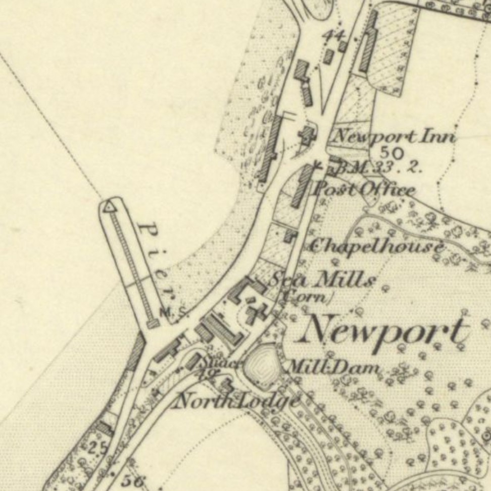
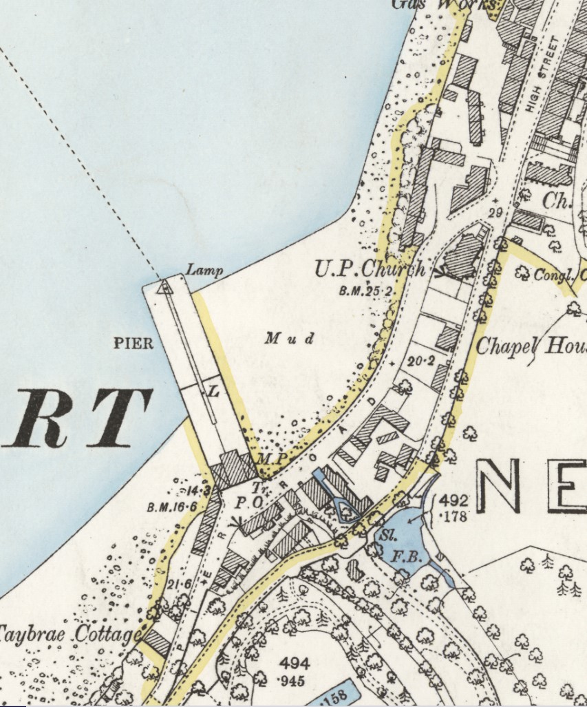
1854 Ordnance Survey
Original at National Library of Scotland.
1869 Plans and sections of ferries across River Tay and relative works at Dundee [& Forgan]
Original at National Records of Scotland, ref. RHP34382
More information on the railway proposals here
This plan is part of the Tay Ferries Bill, 1869/70, which was to extend / build a new pier at Dundee; to vest in the Caledonian Railway Co the Tay Ferry which at present they only manage; etc. It is not known why the Railway Company wanted to take ownership of the Newport Inn - was it to make it a Caledonian Hotel? There was much opposition to the Bill locally and it was eventually defeated in Parliament.

| Ref | Description | Owner or reputed owner | Occupier | Location |
|---|---|---|---|---|
| 1 | Pier & breakwater | Tay Ferries Trustees; Caledonian Railway | Caledonian Railway | Location |
| 2 | Porter's office & parcel shed | Tay Ferries Trustees; Caledonian Railway | Caledonian Railway | |
| 3 | Porter's office & parcel office | Tay Ferries Trustees; Caledonian Railway | Caledonian Railway | |
| 4 | Coal shed | Tay Ferries Trustees; Caledonian Railway | Samuel Sercombe | |
| 5 | Waiting room & boothy [listed with flesher's shop on original] | Tay Ferries Trustees; Caledonian Railway | Caledonian Railway | Location |
| 5 | Flesher's shop [listed with Waiting Room in original] | Tay Ferries Trustees; Caledonian Railway | Samuel Sercombe | Location |
| 6 | Coal shed | Tay Ferries Trustees; Caledonian Railway | Caledonian Railway | Location |
| 7 | Beach of River Tay above high water mark, boat stance & vacant ground or road | John Berry; Henry Stewart; Tay Ferries Trustees; Caledonian Railway | John Harris; Caledonian Railway | |
| 8 | Vacant ground above high water mark | John Berry; Henry Stewart; Tay Ferries Trustees; Caledonian Railway | John Harris; Caledonian Railway | |
| 9 | Garden ground, dykes & hedges | Andrew Smith | Andrew Smith | Location |
| 10 | Dwelling house | Andrew Smith | Andrew Smith | Location |
| 11 | Washing house or outhouse | Andrew Smith | Andrew Smith | Location |
| 12 | Coal house or outhouse | Andrew Smith | Andrew Smith | Location |
| 13 | Road or statute labour road | Statute Labour Road Trustees; Tay Ferries Trustees; Caledonian Railway | Caledonian Railway; The Public | |
| 14 | Stables, hay lofts, carriage sheds, harness room, granary & cellars | John Berry | David Dickson (lessee & occupier) | Location |
| 15 | Water closets | John Berry | David Dickson (lessee & occupier) | |
| 16 | Court & entrance to inn, road or access to stables & other outhouses, & outer court or vacant ground | John Berry | David Dickson (lessee & occupier) | |
| 17 | Coal shed | John Berry | David Dickson (lessee & occupier) | |
| 18 | Hall or carriage shed | John Berry | David Dickson (lessee & occupier) | Location |
| 19 | Piggery & shed | John Berry | David Dickson (lessee & occupier) | |
| 20 | Water closet | John Berry | David Dickson (lessee & occupier) | |
| 21 | Inn called 'Newport Inn' | John Berry | David Dickson (lessee & occupier) | Location |
| 22 | Coal shed & water closet | John Berry | David Dickson (lessee & occupier) | |
| 23 | Store | John Berry | David Dickson (lessee & occupier) | |
| 24 | Turnpike road or street | Turnpike Trustees; John Berry | The Public | |
| 25 | Burn or stream between high & low water mark of river or firth of Tay | The Crown; Lords Commiss. of Admiralty; Board of … Trade …; Tay Ferries Trustees; Caledonian Railway | Covered with water at full tide; Caledonian Railway; The Public | |
| 26 | River or firth of Tay above low water mark & land covered with water | The Crown; Lords Commiss. of Admiralty; Board of … Trade …; Tay Ferries Trustees; Caledonian Railway | Covered with water at full tide; Caledonian Railway; The Public | |
| 27 | River or firth of Tay above low water mark & land covered with water | The Crown; Lords Commiss. of Admiralty; Board of … Trade …; Tay Ferries Trustees; Caledonian Railway | Covered with water at full tide; Caledonian Railway; The Public | |
| 28 | River or firth of Tay below low water mark & land covered with water | The Crown; Lords Commiss. of Admiralty; Board of … Trade …; Tay Ferries Trustees; Caledonian Railway | Covered with water at full tide; Caledonian Railway; The Public | |
| 29 | Woodland, beach of river or firth of Tay & vacant ground | John Berry; Sarah Crawford Berry | Sarah Crawford Berry | Location |
1872 Plan of Tay Ferries showing works, lands and houses to be acquired
Original at National Records of Scotland, ref. RHP24570
More information on the railway proposals here
This plan appears, from the date, to refer to the takeover by the Dundee Harbour Trustees of the whole running and management of the Tay Ferry from the Caledonian Railway Co.
| Ref | Description | Owner or reputed owner | Occupier | Location |
|---|---|---|---|---|
| 2 | Porter's office & parcels shed | |||
| 3 | Porter's office & parcels office | |||
| 4 | Coal Shed | Samuel Sercombe | ||
| 5 | Urinal | |||
| 6 | Coal shed | Tay Ferries | ||
| 7 | Waiting room & bothy | Tay Ferries | Location | |
| 8 | Butcher's shop | Samuel Sercombe | Location | |
| 9 | Boatshed | Newport Amateur Rowing Club per William Hart | Location |
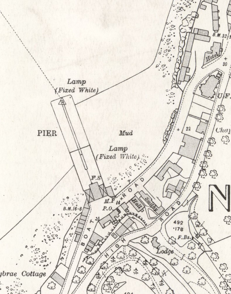
1895 Ordnance Survey
Original at National Library of Scotland.
1914 Ordnance Survey
Original at National Library of Scotland.
1966 Ordnance Survey
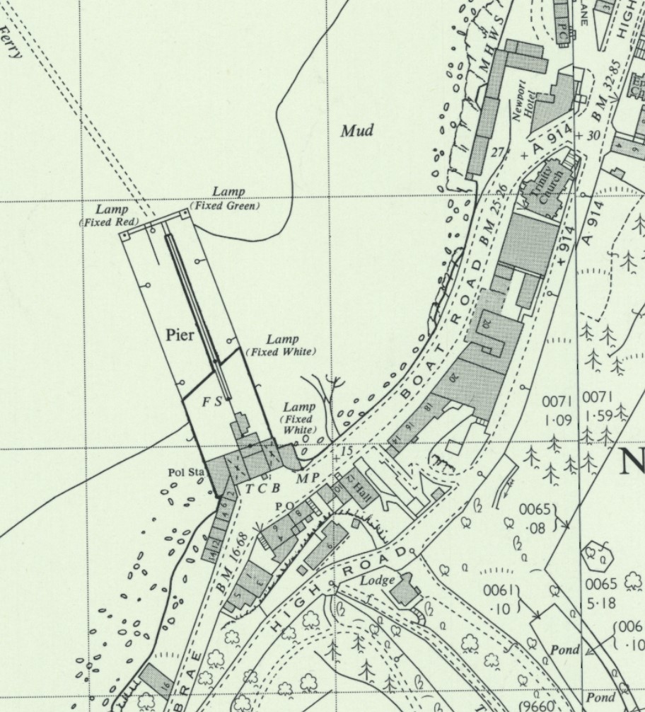
Original at National Library of Scotland.
Return to: Home Page Railway Plans Railway Plan References