
Location : old house [south 1], High Street
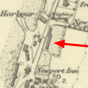
Photo / old map: OS 6 inch map, 1854. Reproduced with the permission of the National Library of Scotland.
 = Property demolished or site redeveloped
Notes: demolished after 1871
Location and Old Maps
Latitude, longitude: 56.439841,-2.941518
View location on the 1855 6-inch map, the 1895 25-inch map, the 1914 25-inch map, the 1966-73 25-inch map, or a 1944-50 aerial photograph at the National Library of Scotland website.
Nearby properties (demolished in red): (Newport School, 5, Blyth Street) 2 Blyth Street 4 Blyth Street shop, 1, Cupar Road shop, 3, Cupar Road shop, formerly 5, Cupar Road shop, 7, Cupar Road shop, 9, Cupar Road 6 Cupar Road 4 Cupar Road shop, formerly 2, Cupar Road (Farm steading, Cupar Road) (old tollhouse, Cupar Road) (Burgh Yard, formerly 11, Granary Lane) (Newport harbour pack house, Granary Lane) (Caldwell, Granary Lane) (Old Granary [1], High Street) (Old Granary [2], High Street) (Old Granary [3], High Street) (Old Granary [4], High Street) (Old Granary [5], High Street) (Old Granary [6], High Street) (Old Granary [7], High Street) (Old Granary [8], High Street) (Old Granary [9], High Street) (Old Granary [10], High Street) (Old Granary [11], High Street) 3 High Street 5 High Street 7 High Street shop, 9, High Street shop, 11, High Street 12 High Street shop, 13, High Street 14 High Street shop, 15, High Street shop, 16, High Street 18 High Street 20 High Street 22 High Street shop, 24, High Street 26 High Street 28a, High Street shop, 28, High Street shop, 30, High Street shop, 32, High Street 34 High Street 36 High Street shop, 38, High Street shop, 40, High Street shop, 46, High Street shop, 48, High Street shop, 52, High Street shop, 54, High Street shop, 50, High Street (house at gasworks, High Street) (Gas Office, High Street) downstairs property, 9, High Street (Newport House, High Street) (old house [north 1], High Street) (old house [north 2], High Street) (old house [north 3], High Street) (old house [south 2], High Street) (old house [south 3], High Street) (old house [south 4], High Street) 2 Tay Street
Later use of the site : 38 High Street
Old Addresses (any dates are approximate and are usually the latest occurence of the address)
| 4 Newport Road | 1861 |
House Names (any dates are approximate and are usually the latest occurence of the name)
| old house [south 1] |
Directory entries (before 1975)
| - |
Census records
| Year | Address | Head | Notes | Rooms | ||||
|---|---|---|---|---|---|---|---|---|
| 1871 | High Street | Balsillie | Elizabeth | 2 | View household | |||
| 1861 | 4 Newport Road | Kay | Robert | 2 | View household | |||
| 1851 | Keay | Robert | View household | |||||
| 1841 | Newport Village | Bell | George | View household |
Valuation Roll entries
| Year | No. | Property | Proprietor | Tenant | Occupier | Value | |||
|---|---|---|---|---|---|---|---|---|---|
| - |
Railway Map References:
| Plan | Year | Ref | Description | Owner or reputed owner | Occupier | [Comments] |
|---|---|---|---|---|---|---|
| RHP85261 (E & N) | 1845 | 55 | Dwelling houses & garden ground | William Berry | William Turnbull, John Bell, Alexander Milne, Alexander Harris, Mrs Menzies Mackie, John Kidd, Thomas Pinn & Mrs Catherine Brown | [At the top of the High St] |
Other Sightings:
| Year | Detail | Source |
|---|---|---|
| 1825 | Building shown on map: Ref. 8, Old Boatmen's Houses | National Library of Scotland, Plan of the coast from Newport to Craighead, 1824-25, John Steedman |
| 1817 | Building shown on map | National Library of Scotland Survey of the Harbour of Newport, Stevenson, 1817 |
| 1805 | Building shown on map of Tayfield Estate. | No image available. National Records of Scotland, RHP30436, Plan of Tayfield. |
Early Sasines:
| - |
Return to: Home Page Present-day Addresses Properties Map Old House Names Directories Valuation Rolls Sasines Census