
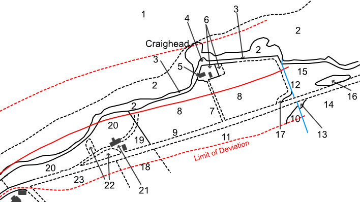
Railway Plan for the proposed Glasgow & Dundee Junction Railway, November 1845 (page 1 - East Newport)
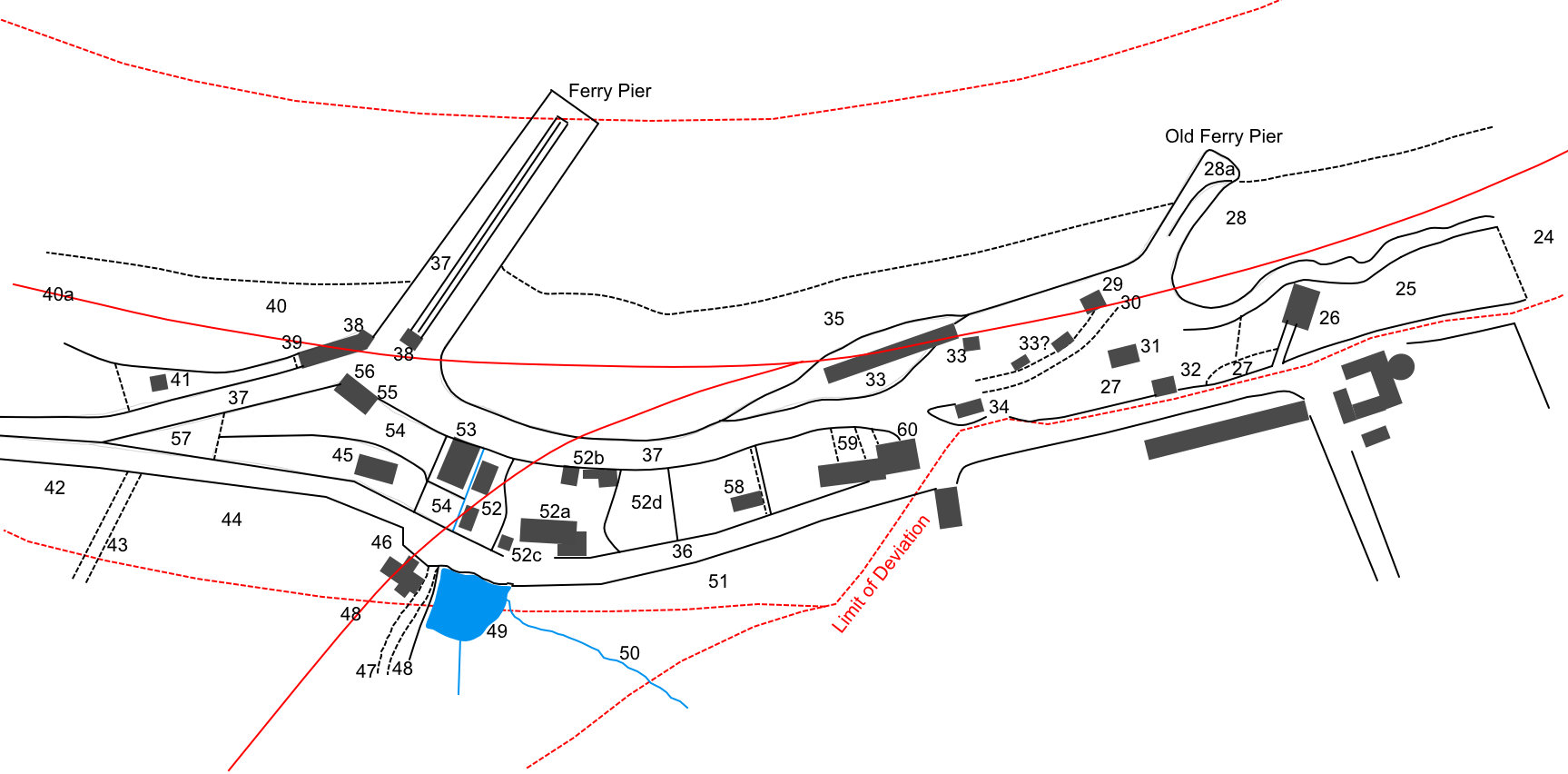
Plans of Parts of Newport & Woodhaven in 1845
Background information about this railway plan is in the blog - A Tunnel Under Tayfield.
Glasgow & Dundee Junction Railway.
Tunnels shown as blue dotted lines.
Floating bridge shown as a purple dotted line.
The Glasgow & Dundee Junction Railway Company proposed, in 1845, a railway to run from Dundee to Glasgow by Kinross and Stirling. The line itself would start at Craighead, the Dundee connection would have to be made by ferry.
This application for Parliamentary approval was for a line from Craighead to Newport pier. From there 2 choices were offered: (1) a line along the shore past Woodhaven and Scroggieside, round a bend to pass Wormit Farm, then through the Wormit Gap in the hills and round the hill at Sandford. The main line would run from there west through open countryside past Kilmany, Luthrie and Letham to Auchtermuchty, then on to Kinross and eventually Stirling and Glasgow. (2) a line heading south past Tayfield and Friarton, partly in tunnel, then turning southwest to join up with option (1) at Easter Kinnear Farm. Both options would connect to a branch to Cupar and St Andrews.
The line was never built, instead a line was built by the Edinburgh & Northern Railway Company from Cupar via Leuchars to Tayport.
These sketch maps below are taken from the Glasgow & Dundee Junction Railway plans, November 1845, at the National Records of Scotland, ref. RHP85254.
The solid red line indicates the positon of the proposed railway line. Apart from this, the plans show who owned, lived in, and had an interest in, every property along the proposed line. The properties are limited in scope to a small distance on either side of the railway line (the 'limits of deviation' - shown by red dashed lines), which is why some buildings are detailed on these plans while others, which are possibly more important, are not mentioned.
The numbers refer to the details given in the accompanying Book of Reference, given below.
Next page for West Newport and Woodhaven
[The map below covers the area from beneath the Tay Road Bridge on the east, to James Street on the west.]
[The map below covers the area from William Street on the east, to the top of Boat Brae on the west. No. 34 is the Newport Hotel. The map shows the 2 route options from Newport Pier: (1) west to Wormit and (2) south through Tayfield.]
There is another plan of this area for the Edinburgh & Northern Railway.
Next page for West Newport and Woodhaven
There are 67 records.| Co. | Year | Plan | Ref | Description | Owner or reputed owner | Occupier | [Comments] | Location |
|---|---|---|---|---|---|---|---|---|
| G & D J | 1845 | RHP85254 | 1 | The estuary or Firth of the River Tay | The Crown, Her Majesty's Commissioners of Woods & Forests, the Lords Commissioners of the Admiralty, the Trustees of the Harbour of Dundee | |||
| G & D J | 1845 | RHP85254 | 2 | Rocks and alveus, being the strand or sea shore of the River Tay, salmon fishings in the said river | William Berry, James Wilson, the Crown, Her Majesty's Commissioners of Woods & Forests | Alexander Harris (lessee) | ||
| G & D J | 1845 | RHP85254 | 2a | Arable | James Wilson (proprietor), William Berry (superior) | James Wilson | ||
| G & D J | 1845 | RHP85254 | 3 | Footpath or road | William Berry, James Wilson | The Public | ||
| G & D J | 1845 | RHP85254 | 4 | Garden ground and outbuilding | James Wilson (proprietor), William Berry (superior) | James Wilson | ||
| G & D J | 1845 | RHP85254 | 5 | Dwelling house and garden ground | James Wilson (proprietor), William Berry (superior) | James Wilson | [Craighead Cottage - now 109 Tay St] | Location |
| G & D J | 1845 | RHP85254 | 6 | Dwelling house and garden ground | James Wilson (proprietor), William Berry (superior) | William Kay | [another cottage at Craighead, to the east] | Location |
| G & D J | 1845 | RHP85254 | 7 | Occupation road | James Wilson (proprietor), William Berry (superior) | James Wilson | ||
| G & D J | 1845 | RHP85254 | 8 | Arable | James Wilson (proprietor), William Berry (superior) | James Wilson | ||
| G & D J | 1845 | RHP85254 | 9 | Turnpike road | Trustees of St Andrews District of Turnpike Roads in the County of Fife | The Public | ||
| G & D J | 1845 | RHP85254 | 10 | Plantation | James Wilson (proprietor), William Berry (superior) | James Wilson | ||
| G & D J | 1845 | RHP85254 | 11 | Arable | James Wilson (proprietor), William Berry (superior) | James Wilson | ||
| G & D J | 1845 | RHP85254 | 12 | Burn or stream | James Wilson, Mrs Elizabeth Dykes or Rogers, John Rogers (proprietors), William Berry (superior) | James Wilson, James Rogers | ||
| G & D J | 1845 | RHP85254 | 13 | Plantation | Mrs Elizabeth Dykes or Rogers, John Rogers (proprietors), William Berry (superior) | James Rogers (lessee & occupier) | ||
| G & D J | 1845 | RHP85254 | 14 | Arable | Mrs Elizabeth Dykes or Rogers, John Rogers (proprietors), William Berry (superior) | James Rogers (lessee & occupier) | ||
| G & D J | 1845 | RHP85254 | 15 | Arable | Mrs Elizabeth Dykes or Rogers, John Rogers (proprietors), William Berry (superior) | James Rogers (lessee & occupier) | [now the site of 113/115 Tay St] | |
| G & D J | 1845 | RHP85254 | 16 | Plantation | Mrs Elizabeth Dykes or Rogers, John Rogers (proprietors), William Berry (superior) | James Rogers | ||
| G & D J | 1845 | RHP85254 | 17 | Occupation road | James Wilson, William Berry | William Berry, Alexander Harris | ||
| G & D J | 1845 | RHP85254 | 18 | Arable | William Berry | James Wilson (lessee & occupier) | ||
| G & D J | 1845 | RHP85254 | 19 | Arable | William Berry | James Wilson (lessee & occupier) | ||
| G & D J | 1845 | RHP85254 | 20 | Pasture, marsh, rocks and rough ground | William Berry | James Wilson (lessee); John Harris (occupier) | ||
| G & D J | 1845 | RHP85254 | 21 | Dwelling house, barn, byre, stable, sheds and outbuildings | William Berry | James Wilson (lessee); John Harris (occupier) | [Kempstane] | Location Location 2 |
| G & D J | 1845 | RHP85254 | 22 | Garden ground | William Berry | James Wilson (lessee); John Harris (occupier) | ||
| G & D J | 1845 | RHP85254 | 23 | Arable | William Berry | James Wilson (lessee & occupier) | ||
| G & D J | 1845 | RHP85254 | 24 | Pasture, marsh, rocks, rough ground & footpaths | William Berry | William Turnbull, Alexander Harris | [Ran from the foot of William St to almost the foot of James St] | |
| G & D J | 1845 | RHP85254 | 25 | Pasture & rough ground | William Berry | Mrs Ann Cramond or Brand | [This extended from west of the granary as far east as the foot of William St] | |
| G & D J | 1845 | RHP85254 | 26 | Granary, warehouse & access road, rocks & rough ground | James Wilson (proprietor), William Berry (superior) | John Aymer, James Wilson | [Opposite the bottom of the Cupar Road] | Location Location 2 Location 3 |
| G & D J | 1845 | RHP85254 | 27 | Rocks, rough pasture, access road & footpaths | William Berry | James Wilson, John Aymer, Mrs Ann Cramond or Brand | ||
| G & D J | 1845 | RHP85254 | 28 | Port or harbour | William Berry | William Berry, Mrs Ann Cramond or Brand | ||
| G & D J | 1845 | RHP85254 | 28a | Old ferry pier | William Berry | William Berry, Mrs Ann Cramond or Brand | ||
| G & D J | 1845 | RHP85254 | 29 | Warehouse & granary | William Berry | James Bogie, James Charles Lindsay | Location Location 2 Location 3 | |
| G & D J | 1845 | RHP85254 | 30 | Road to pier & harbour | William Berry | William Berry, Mrs Ann Cramond or Brand, the Public | ||
| G & D J | 1845 | RHP85254 | 31 | Stables & sheds | William Berry | Michael Smith, David Spence | Location | |
| G & D J | 1845 | RHP85254 | 32 | Building formerly used as a police cell | William Berry | [Site of 13/15 High St] | Location | |
| G & D J | 1845 | RHP85254 | 33 | Stables, sheds, granaries, lofts, outbuildings & courts | William Berry | Charles Mitchell (lessee & occupier) | [part of Newport Hotel] | Location |
| G & D J | 1845 | RHP85254 | 34 | Dwelling house & outbuildings | William Berry | Charles Mitchell (lessee & occupier) | [Actually the Newport Hotel] | Location |
| G & D J | 1845 | RHP85254 | 35 | Alveus strand of the River Tay & salmon fishings in the said river | Henry Stewart, the Crown, H M Commissioners of Woods & Forests | Alexander Robertson (lessee & occupier) | [Shown as St Fort's fishings (not Tayfield's), leased to Alexander Robertson] | |
| G & D J | 1845 | RHP85254 | 36 | Statute Labour road | Trustees of St Andrews District of Statute Labour Roads in the county of Fife | The Public | ||
| G & D J | 1845 | RHP85254 | 37 | Ferry harbour, piers, landing places, & approaches, or Turnpike or Statute Labour road | H M Commissioners for the Issue of Exchequer Loans, Dundee Banking Co, Scottish Central Railway Co, Trustees for the Erecting Improving Regulating & Maintaining Ferries and Passages across the River Tay in the Counties of Fife & Forfar, Trustees of the Cupar District of Turnpike or Statute Labour Roads in the County of Fife | Dundee Banking Co, Scottish Central Railway Co, the Public | ||
| G & D J | 1845 | RHP85254 | 38 | Dwelling house, sheds & outbuildings | H M Commissioners for the Issue of Exchequer Loans, Dundee Banking Co, Scottish Central Railway Co, Trustees for the Erecting Improving Regulating & Maintaining Ferries and Passages across the River Tay in the Counties of Fife & Forfar | Dundee Banking Co, Scottish Central Railway Co | Location | |
| G & D J | 1845 | RHP85254 | 39 | Occupation road | William Berry | William Berry | ||
| G & D J | 1845 | RHP85254 | 40 | Alveus strand of the River Tay & salmon fishings in said river | William Berry, Henry Stewart, the Crown, Her Majesty's Commissioners of Woods and Forests | Alexander Robertson (lessee & occupier) | ||
| G & D J | 1845 | RHP85254 | 40a | Alveus strand of the River Tay | Andrew Smith, Richard Gleadhill Holden, Arthur Baird, Mrs William Just, Mrs Barbara Mackie or Just, Robert Just, David Just, John Just, George Just, Alexander Kermath, Miss Margaret Mackie, Mrs Margaret Walker or Duncan, William Duncan, Mrs Margaret Hill or Bell, Alexander Jack, Andrew Kilgour, Alexander Ritchie, Margaret & Helen Ritchie, Thomas Just | [These are the proprietors of all the houses from here (in order) to just east of Wellgate House, i.e. all the houses on Broadhaugh plus Andrew Smith's] | ||
| G & D J | 1845 | RHP85254 | 41 | Dwelling house, outbuildings & garden | Andrew Smith (proprietor), William Berry (superior) | Andrew Smith | Location | |
| G & D J | 1845 | RHP85254 | 42 | Arable | William Berry | John Just (lessee & occupier) | ||
| G & D J | 1845 | RHP85254 | 43 | Occupation road | William Berry | John Just (lessee & occupier) | ||
| G & D J | 1845 | RHP85254 | 44 | Arable | William Berry | John Just (lessee & occupier) | ||
| G & D J | 1845 | RHP85254 | 45 | Dwelling houses, outhouses & gardens | William Berry | John Dorward | [Seamills Cottages] | Location Location 2 |
| G & D J | 1845 | RHP85254 | 46 | Dwelling house | William Berry | Andrew Black | [Tayfield North Lodge] | Location |
| G & D J | 1845 | RHP85254 | 47 | Private road, approach to house of Tayfield | William Berry | William Berry | ||
| G & D J | 1845 | RHP85254 | 48 | Pleasure ground & shrubbery | William Berry | William Berry | ||
| G & D J | 1845 | RHP85254 | 49 | Mill-dam & trees | William Berry | John Just (lessee & occupier) | ||
| G & D J | 1845 | RHP85254 | 50 | Burn or stream | William Berry | John Just (lessee & occupier) | ||
| G & D J | 1845 | RHP85254 | 51 | Arable | William Berry | William Berry | ||
| G & D J | 1845 | RHP85254 | 52 | Mills, mill-houses & leads, outbuildings, court & access roads | William Berry | John Just (lessee & occupier) | [Seamills] | Location |
| G & D J | 1845 | RHP85254 | 52a | Dwelling house, load-house, kiln, shed, outbuildings, rough ground & footpaths | William Berry | John Just (lessee & occupier), James Brand (occupier) | [Seamills farm buildings] | Location Location 2 |
| G & D J | 1845 | RHP85254 | 52b | Dwelling house, barn, byre, stable, outbuildings, barnyard & court | William Berry | John Just (lessee & occupier) | [Seamills farm buildings] | Location |
| G & D J | 1845 | RHP85254 | 52c | Occupation road | William Berry | William Berry, John Just | ||
| G & D J | 1845 | RHP85254 | 52d | Garden ground | William Berry | John Just (lessee & occupier), James Brand (occupier) | ||
| G & D J | 1845 | RHP85254 | 53 | Weigh and pack house, warehouse, granary & outbuildings | William Berry | James Bogie, Mrs Ann Cramond or Brand | Location Location 2 | |
| G & D J | 1845 | RHP85254 | 54 | Rocks, rough ground, pasture ground, byre, court, private road & wood | William Berry | Mrs Ann Cramond or Brand | ||
| G & D J | 1845 | RHP85254 | 55 | Dwelling house | William Berry | Charles Mitchell (lessee & occupier) | ||
| G & D J | 1845 | RHP85254 | 56 | Shed | William Berry | Dundee Banking Co, Scottish Central Railway Co | ||
| G & D J | 1845 | RHP85254 | 57 | Plantation | William Berry | William Berry | ||
| G & D J | 1845 | RHP85254 | 58 | Dwelling house, outbuildings & garden ground | William Berry | James Smith | [This was Chapel House] | Location Location 2 Location 3 |
| G & D J | 1845 | RHP85254 | 59 | Dwelling houses, outbuildings, garden ground & footpath | William Berry | Alexander Muir, John Duncan, Thomas Clark | Location Location 2 Location 3 | |
| G & D J | 1845 | RHP85254 | 60 | Dwelling house, outbuildings & garden | William Berry | Charles Mitchell, Mrs Margaret Foreman or Henderson | [Formerly the old St David's Inn; on the site of Trinity Church] | Location Location 2 |
Next page for West Newport and Woodhaven
Return to: Home Page Railway Plans Railway Plan References