
Location : Newport House, High Street
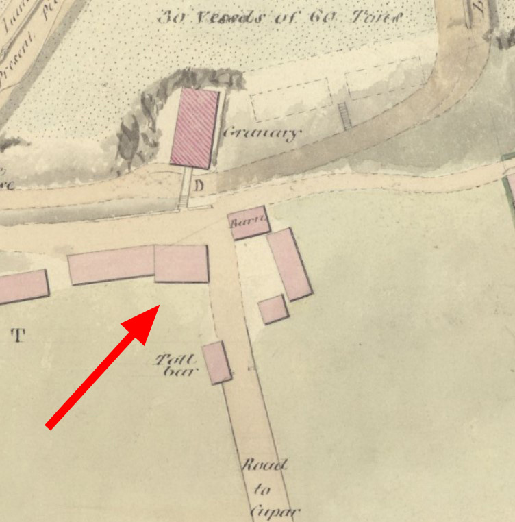
Photo / old map: Stevenson, Survey for harbour …, 1817. Reproduced with the permission of the National Library of Scotland.
 = Property demolished or site redeveloped
Notes: Demolished between 1817 and 1825.
Commentary
The entries in local taxation returns listed here are tentative, whether the entries are for this property or the inn at St Davids - I am still not certain, in particular, about John Hay. The speculation also applies to 'Andrew Rodger at the Braehead'.
Location and Old Maps
Latitude, longitude: 56.440161,-2.941352
View location on the 1855 6-inch map, the 1895 25-inch map, the 1914 25-inch map, the 1966-73 25-inch map, or a 1944-50 aerial photograph at the National Library of Scotland website.
Nearby properties (demolished in red): 2 Blyth Street 4 Blyth Street shop, 1, Cupar Road shop, 3, Cupar Road shop, formerly 5, Cupar Road shop, 7, Cupar Road shop, 9, Cupar Road shop, 11, Cupar Road shop, 13, Cupar Road 15 Cupar Road 6 Cupar Road 4 Cupar Road shop, formerly 2, Cupar Road (Newport Toll, Cupar Road) formerly part of 15, Cupar Road (Farm steading, Cupar Road) (old tollhouse, Cupar Road) (Old Granary [1], High Street) (Old Granary [2], High Street) (Old Granary [3], High Street) (Old Granary [4], High Street) (Old Granary [5], High Street) (Old Granary [6], High Street) (Old Granary [7], High Street) (Old Granary [8], High Street) (Old Granary [9], High Street) (Old Granary [10], High Street) (Old Granary [11], High Street) shop, 13, High Street shop, 15, High Street shop, 24, High Street 26 High Street 28a, High Street shop, 28, High Street shop, 30, High Street shop, 32, High Street 34 High Street 36 High Street shop, 38, High Street shop, 40, High Street shop, 46, High Street shop, 48, High Street shop, 52, High Street shop, 54, High Street shop, 50, High Street (house at gasworks, High Street) (Gas Office, High Street) (old house [north 1], High Street) (old house [north 2], High Street) (old house [north 3], High Street) (old house [south 1], High Street) (old house [south 2], High Street) (old house [south 3], High Street) (old house [south 4], High Street) 2 Tay Street 4 Tay Street 6 Tay Street 8 Tay Street
Later use of the site : 54 High Street
Old Addresses (any dates are approximate and are usually the latest occurence of the address)
| - |
House Names (any dates are approximate and are usually the latest occurence of the name)
| Newport House |
Directory entries (before 1975)
| - |
Census records
| - |
Valuation Roll entries
| Year | No. | Property | Proprietor | Tenant | Occupier | Value | |||
|---|---|---|---|---|---|---|---|---|---|
| - |
Early taxation records (either at this exact location or an earlier one)
| Date | Taxpayer | Taxable items | Duty paid | Tax | Source ref | Note |
|---|---|---|---|---|---|---|
| 1 … 1791 | Andrew Rodger in Newport | 1 cart with 2 wheels, duty 2s. | 2s. + 2.4d. | Cart Tax | E326/7/12/81 | |
| 27 Aug 1790 | Andrew Rodger at Newport | 1 cart with 2 wheels, duty 2s. | 2s. | Cart Tax | E326/7/10/77 | |
| 24 Jul 1789 | Andrew Rodger at Newport | 1 cart with 2 wheels, duty 2s. | 2s. | Cart Tax | E326/7/8/83 | |
| 2 Aug 1788 | Andrew Rodger at the Braehead | 1 cart with 2 wheels, duty 2s. | 2s. | Cart Tax | E326/7/6/89 | |
| 10 ... 1787 | Andrew Rodger at the Braehead | 1 cart with 2 wheels, duty 2s. | 1s. | Cart Tax | E326/7/4/81 | |
| - - 1776 | William Simpson at Newport | U.h. 10 [wind.] | House & Window Tax | E326/1/46/77 | ||
| 3 Aug 1775 | William Simpson at Newport | 1 house, 10 windows | 8s. 4d. (windows) + 1s. (house) | House & Window Tax | E326/1/46/54 | |
| 30 Jul 1774 | Alexander Todd in Newport | 1 house, 10 windows | 8s. 4d. (windows) + 1s. (house) | House & Window Tax | E326/1/46/33 | |
| 15 Jul 1773 | Alexander Todd Newport | 1 house, 10 windows | 8s. 4d. (windows) + 1s. (house) | House & Window Tax | E326/1/46/11 | |
| 19 Jul 1772 | Alexander Tod in Newport | 1 house, 10 windows | 8s. 4d. (windows) + 1s. (house) | House & Window Tax | E326/1/45/161 | |
| 31 Aug 1771 | Mr Alexander Tod Newport | 1 house, 10 windows | 8s. 4d. (windows) + 1s. (house) | House & Window Tax | E326/1/45/140 | |
| 23 Aug 1770 | Mr Johnston at Newport | 1 house | 1s. | House & Window Tax | E326/1/45/121 | |
| 18 Aug 1769 | Mr Johnston Newport | 1 house, 7 windows | 1s. 2d. (windows) + 1s. (house) | House & Window Tax | E326/1/45/102 | |
| .. Sep 1768 | Mr Johnston at Newport | 1 house, 7 windows | 1s. 2d. (windows) + 1s. (house) | House & Window Tax | E326/1/45/82 | |
| 8 Feb 1763 | Thomas Patt in [Newport] | 1 house | 6d. | House & Window Tax | E326/1/44/46 | |
| 15 Jun 1762 | Thomas Pate in [Newport] | 1 house | 6d. | House & Window Tax | E326/1/44/13 | |
| - Feb 1762 | Thomas Peat in Newport | 1 house | 6d. | House & Window Tax | E326/1/43/222 | |
| 26 Jun 1761 | Thomas Pate in Newport | 1 house | 6d. | House & Window Tax | E326/1/43/190 | |
| 2 Aug 1760 | Margt Steel Newport | 1 house | 6d. | House & Window Tax | E326/1/43/115 | |
| 2 May 1760 | Margt Steil Newport | 1 house | 6d. | House & Window Tax | E326/1/43/80 | |
| 21 Jul 1759 | Margt Steil Newport | 1 house | 6d. | House & Window Tax | E326/1/43/43 | |
| 3 Mar 1759 | Margaret Steel | 1 house | 1s 0d. (a year) | House & Window Tax | E326/1/42/311 |
Other Sightings:
| Year | Detail | Source |
|---|---|---|
| 1835 | Building shown on map: Plan of Marytown now Easter Newport, Neave, 1835 - but note 'this is a copy of the original plan of Marytown' - Newport House had already been demolished by 1835. | No image available. National Records of Scotland, RHP30441, Plan of Marytown now Easter Newport |
| 1825 | No building shown on map: 'Site of Old House' | National Library of Scotland, Plan of the coast from Newport to Craighead, 1824-25, John Steedman |
| 1822 | Location marked by dotted square | No image available. National Records of Scotland, RHP30440, Plan of Newport. |
| 1817 | Building shown on map | National Library of Scotland Survey of the Harbour of Newport, Stevenson, 1817 |
| 1805 | Building shown on map of Tayfield Estate. | No image available. National Records of Scotland, RHP30436, Plan of Tayfield. |
| 1769 | Newport House : shown on map | No image available. University of St Andrews Library, Special Collections, ref. MEP, Plan of Scotscraig Estate, Hope, 1769, redrawn 1954. |
Early Sasines:
| - |
Return to: Home Page Present-day Addresses Properties Map Old House Names Directories Valuation Rolls Sasines Census