
Location : part of Gas Works Lane Granary [5], Granary Lane
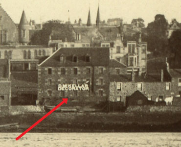
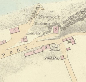
Photo / old map: Map, Steedman 1825, ref. 6. Reproduced with the permission of the National Library of Scotland.
 = Property demolished or site redeveloped
Notes: Demolished. Air-raid shelter later built on part of the site.
Part of a divided property. Other parts: part of Gas Works Lane Granary [1] part of Gas Works Lane Granary [2] part of Gas Works Lane Granary [3] part of Gas Works Lane Granary [4] part of Gas Works Lane Granary [6]
Introduction
Building erected c.1824
Location and Old Maps
Latitude, longitude: 56.439668,-2.942375
View location on the 1855 6-inch map, the 1895 25-inch map, the 1914 25-inch map, the 1966-73 25-inch map, or a 1944-50 aerial photograph at the National Library of Scotland website.
Nearby properties (demolished in red): (formerly stores, 7, Boat Road) (formerly garages & workshop, 9, Boat Road) (former house [1], Granary Lane) (former house [2], Granary Lane) (formerly 5, Granary Lane) (Smithy, formerly 9, Granary Lane) (Burgh Yard, formerly 11, Granary Lane) (Slaughter House, Granary Lane) (part of Gas Works Lane Granary [1], Granary Lane) (part of Gas Works Lane Granary [2], Granary Lane) (part of Gas Works Lane Granary [3], Granary Lane) (part of Gas Works Lane Granary [4], Granary Lane) (part of Gas Works Lane Granary [6], Granary Lane) (former house [3], Granary Lane) (former house [4], Granary Lane) (former house [5], Granary Lane) (former house [6], Granary Lane) (Newport harbour pack house, Granary Lane) (Caldwell, Granary Lane) Newport Hotel, 1, High Street 3 High Street 5 High Street 7 High Street 8 High Street shop, 9, High Street 10 High Street St Mary's Church, High Street shop, 11, High Street shop, 13, High Street shop, 15, High Street (house at gasworks, High Street) (Gas Office, High Street) downstairs property, 9, High Street
Later use of the site : (formerly 5 Granary Lane)
1909-10 Finance Act - Valuation Office: Field Surveys
Old Addresses (any dates are approximate and are usually the latest occurence of the address)
| - |
House Names (any dates are approximate and are usually the latest occurence of the name)
| part of Gas Works Lane Granary [5] | ||
| Mission Hall | to 1885 |
Directory entries (before 1975)
| - |
Census records
| - |
Valuation Roll entries There are 21 entries
| Year | No. | Property | Proprietor | Tenant | Occupier | Value | |||
|---|---|---|---|---|---|---|---|---|---|
| 1922-23 | 749 | Parts of Granary | William Berry per Hagart & Burn Murdoch WS, 140 Princes St, Edinburgh | empty | ruinous | View details | |||
| 1920-21 | 729 | Parts of Granary | William Berry per Hagart & Burn Murdoch WS, 140 Princes St, Edinburgh | empty | ruinous | View details | |||
| 1917-18 | 727 | Parts of Granary | William Berry per Hagart & Burn Murdoch WS, 140 Princes St, Edinburgh | empty | ruinous | View details | |||
| 1915-16 | 723 | Parts of Granary | William Berry per Hagart & Burn Murdoch WS, 140 Princes St, Edinburgh | empty | ruinous | View details | |||
| 1912-13 | 709 | Parts of Granary | William Berry per Hagart & Burn Murdoch WS, 140 Princes St, Edinburgh | James Young, baker | same | 5 | View details | ||
| 1907-08 | 689 | Parts of Granary | William Berry per Hagart & Burn Murdoch WS, 140 Princes St, Edinburgh | James Young, baker | same | 5 | View details | ||
| 1905-06 | 673 | Parts of Granary | William Berry Esq. per Haggart & Burn Murdoch, WS, 140 Princes St, Edinburgh | James Young, baker | same | 5 | View details | ||
| 1903-04 | 664 | Parts of Granary | William Berry Esq. per Haggart & Burn Murdoch, WS, 140 Princes St, Edinburgh | James Young, baker | same | 5 | View details | ||
| 1901-02 | 453 | Parts of Granary | William Berry Esq. per Haggart & Burn Murdoch, WS, 140 Princes St, Edinburgh | James Young, baker | same | 5 | View details | ||
| 1900-01 | 440 | Parts of Granary | William Berry Esq. per Haggart & Burn Murdoch, WS, 140 Princes St, Edinburgh | James Young, baker | same | 5 | View details | ||
| 1899-00 | 411 | Parts of Granary | William Berry Esq. per Haggart & Burn Murdoch, WS, 140 Princes St, Edinburgh | James Young, baker | same | 5 | View details | ||
| 1897-98 | 362 | Parts of Granary | William Berry Esq. per Haggart & Burn Murdoch, WS, 140 Princes St, Edinburgh | James Young, baker | same | 5 | View details | ||
| 1896-97 | 340 | Parts of Granary | William Berry Esq. per Haggart & Burn Murdoch, WS, 140 Princes St, Edinburgh | James Young, baker | same | 5 | View details | ||
| 1892-93 | 144 | Parts of Granary | William Berry Esq. per Haggart & Burn Murdoch, WS, 140 Princes St, Edinburgh | James Young, baker | same | 5 | View details | ||
| 1891-92 | 142 | Parts of Granary | William Berry Esq. per Haggart & Burn Murdoch, WS, 140 Princes St, Edinburgh | James Young, baker | same | 5 | View details | ||
| 1890-91 | 137 | Part of Granary | William Berry Esq. per Haggart & Burn Murdoch, WS, 140 Princes St, Edinburgh | James Young, baker | same | 5 | View details | ||
| 1889-90 | 133 | Granary | William Berry Esq. per Haggart & Burn Murdoch, WS, 140 Princes St, Edinburgh | James Young, baker | same | 5 | View details | ||
| 1885-86 | 124 | Mission Hall | William Berry Esq. per Haggart & Burn Murdoch, WS, Edinburgh | Thomas Roger, grocer | same | 5 | View details | ||
| 1881-82 | 74 | Mission Hall | William Berry Esq. (a minor), per J D Hannan, factor | same | Mission Hall Committee, per Chas. W Scrymgeour, secy. | 5 | View details | ||
| 1878-79 | 81 | Mission Hall | William Berry Esq. (a minor) | same | Newport Association, per James Craig, draper | 5 | View details | ||
| 1875-76 | 80 | Granary or Lecture Room | John Berry Esq. | same | Albert Groethe, engineer for Newport Association | 5 | View details |
Other Sightings:
| Year | Detail | Source |
|---|---|---|
| 1825 | Building shown on map: Ref. 6, Granary newly erected | National Library of Scotland, Plan of the coast from Newport to Craighead, 1824-25, John Steedman |
| 1822 | Building NOT shown on map | No image available. National Records of Scotland, RHP30440, Plan of Newport. |
Early Sasines:
| - |
Return to: Home Page Present-day Addresses Properties Map Old House Names Directories Valuation Rolls Sasines Census