
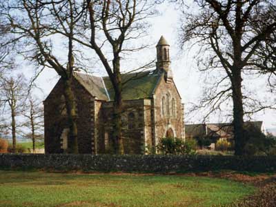
Plot 186: Friarton - 2 roods 5 ells - Forgan Church
This map is an indication of the plot location and size only, and should be used with caution.
Red shading is the plot concerned; yellow indicates a sub-plot created from this one - click the marker to follow the link; green indicates a plot added to this one, or a smaller plot contained within it; blue indicates a plot whose location and/or dimensions are uncertain.
This plot:
| Plot ID | Area | Lot Number | Size | Description | Notes | Properties |
|---|---|---|---|---|---|---|
| 186 | Friarton | Forgan Church | 2 roods 5 ells | |||
Larger plots from which this one is created :
| Plot ID | Area | Lot Number | Size | Description | Notes | Properties |
|---|---|---|---|---|---|---|
| 319 | Landward | miscellaneous plot locations | Map for locations only - not an actual sasine plot. |
Properties remaining on this plot outwith any sub-plots:
Sasine Abridgements (in reverse order):
| Ref | In Brief | Abridgement | Registered | Plot IDs | |
|---|---|---|---|---|---|
| 1844.01397 | St Fort to Heritors of Forgan Parish | Heritors of Parish of Forgan seised 2 roods 5 ells ground of estate of St Fort, pt of farm of Easter Friarton, with the church t/on - on disp by Henry Stewart, St Fort, 25 Sep 1843 | 12 Feb 1844 | 186 |
Abbreviations in the notes
t/on - thereon; t/p - turnpike; dw - dwelling; ho - house; pt - part; pce - piece; grnd - ground; bldg - building; Tr/Trs - Trustee/Trustees; dec - deceased; ... - words omitted; pol - poles; yd - square yards; : - bounded; rd - road; ' - feet; " - inches;
Basic Types of Sasine Abridgements Worked example explaining the sasine transactions on the property pages Sasine entries - background information and explanation
Names in Sasines:
| 1844.01397 | Forgan parish church |
| 1844.01397 | Stewart, St Fort |
Return to: Home Page Sasines Forgan Church