
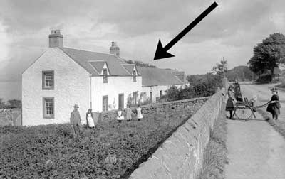
Location : Scroggieside Farm Steading, Riverside Road
 = Property demolished or site redeveloped
Notes: demolished
Introduction
Farm steading, part used as accommodation.
Location and Old Maps
Latitude, longitude: 56.4286,-2.9716
View location on the 1855 6-inch map, the 1895 25-inch map, the 1914 25-inch map, the 1966-73 25-inch map, or a 1944-50 aerial photograph at the National Library of Scotland website.
Nearby properties (demolished in red): 1 North Terrace 2 North Terrace 3 North Terrace 25 Riverside Road 27 Riverside Road 29 Riverside Road 31 Riverside Road 33 Riverside Road 34 Riverside Road 36 Riverside Road 38 Riverside Road 40 Riverside Road 42 Riverside Road (Scroggieside Farmhouse, Riverside Road) (Scroggieside shop, Riverside Road)
Later use of the site : 29 Riverside Road
Information and Photographs on Other Sites (open in a new window)
| Scroggieside Farm source: Photopolis |
| Scroggieside Farm street view source: Photopolis |
Old Addresses (any dates are approximate and are usually the latest occurence of the address)
| Newburgh Road |
House Names (any dates are approximate and are usually the latest occurence of the name)
| Scroggieside Farm Cottage |
Directory entries (before 1975)
| Source | Entry | ||
|---|---|---|---|
| 1891-92 Lamburn dir | Low, Geo., Scroggieside : Farmers |
Census records
| Year | Address | Head | Notes | Rooms | ||||
|---|---|---|---|---|---|---|---|---|
| 1891 | Scroggieside | Lowe | David | 1 | View household | |||
| 1881 | Scroggieside Cottage | Roy | James | [out of sequence] | 2 | View household | ||
| 1871 | Scroggieside Cottage | Johnston | Henry | 1 | View household |
Valuation Roll entries There are 4 entries
| Year | No. | Property | Proprietor | Tenant | Occupier | Value | |||
|---|---|---|---|---|---|---|---|---|---|
| 1892-93 | 21 | House | Henry Scrymgeour Wedderburn Esq. per William Duncan SSC, 18 York Place, Edinburgh | Robert Hay, farmer | George Lowe, dairyman; IO | View details | |||
| 1891-92 | 21 | House | Henry Scrymgeour Wedderburn Esq. per William Duncan SSC, 18 York Place, Edinburgh | Robert Hay, farmer | George Lowe, dairyman; IO | View details | |||
| 1890-91 | 20 | House | Henry Scrymgeour Wedderburn Esq. per William Duncan SSC, 18 York Place, Edinburgh | Robert Hay, farmer | George Lowe, dairyman; IO | View details | |||
| 1889-90 | 19 | House | Henry Scrymgeour Wedderburn Esq. per William Duncan SSC, 18 York Place, Edinburgh | Robert Hay, farmer | George Law, dairyman; IO | View details |
Early Sasines:
Sasine Plots:
| Plot: 142 view details | Wormit | 3 roods 4 pol 3 yd | E portion of 1 acre 2 rood 30 pol, on N of turnpike to Newport | Scroggieside Farm, 27-29 Riverside Rd, & North Tce |
Sasine Abridgements:
| Ref | In Brief | Abridgement | Recorded | Plots | |
|---|---|---|---|---|---|
| 1891.01573 | loan by Robert Logan McGregor | Bond for £150 & disp by Thomas Watson to Robert Logan McGregor, solicitor, Dundee of 3 roods 4 pol 3 yds grnd on N of highway from Newport, being E pt of 1 acre 2 roods 30 poles known as Scroggieside | 27 Nov 1891 | 142 | |
| 1891.01572 | William Mitchell to Thomas Watson | Disp by William Mitchell to Thomas Watson, Varna Cottage, Wormit of 3 roods 4 pol 3 yds grnd on N of highway from Newport, being E pt of 1 acre 2 roods 30 poles known as Scroggieside | 27 Nov 1891 | 142 139 |
Abbreviations in the notes
t/on - thereon; t/p - turnpike; dw - dwelling; ho - house; pt - part; pce - piece; grnd - ground; bldg - building; Tr/Trs - Trustee/Trustees; dec - deceased; ... - words omitted; pol - poles; yd - square yards; : - bounded; rd - road; ' - feet; " - inches;
Basic Types of Sasine Abridgements Worked example explaining the sasine transactions on the property pages Sasine entries - background information and explanation
Return to: Home Page Present-day Addresses Properties Map Old House Names Directories Valuation Rolls Sasines Census