
Location : Caldwell, Granary Lane
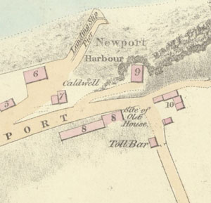
Photo / old map: Map, Steedman 1825. Reproduced with the permission of the National Library of Scotland.
 = Property demolished or site redeveloped
Notes: location only
Commentary
Map shows a small circle - so it may be a well. The 'biggings of Caldwell' mentioned in Dundee Guildry Minutes 1713.
Location and Old Maps
Latitude, longitude: 56.439948,-2.942057
View location on the 1855 6-inch map, the 1895 25-inch map, the 1914 25-inch map, the 1966-73 25-inch map, or a 1944-50 aerial photograph at the National Library of Scotland website.
Nearby properties (demolished in red): (former house [1], Granary Lane) (former house [2], Granary Lane) (formerly 5, Granary Lane) (Burgh Yard, formerly 11, Granary Lane) (Slaughter House, Granary Lane) (part of Gas Works Lane Granary [1], Granary Lane) (part of Gas Works Lane Granary [2], Granary Lane) (part of Gas Works Lane Granary [3], Granary Lane) (part of Gas Works Lane Granary [4], Granary Lane) (part of Gas Works Lane Granary [5], Granary Lane) (part of Gas Works Lane Granary [6], Granary Lane) (former house [3], Granary Lane) (former house [4], Granary Lane) (former house [5], Granary Lane) (former house [6], Granary Lane) (Newport harbour pack house, Granary Lane) (Old Granary [1], High Street) (Old Granary [2], High Street) (Old Granary [3], High Street) (Old Granary [4], High Street) (Old Granary [5], High Street) (Old Granary [6], High Street) (Old Granary [7], High Street) (Old Granary [8], High Street) (Old Granary [9], High Street) (Old Granary [10], High Street) (Old Granary [11], High Street) 3 High Street 5 High Street 7 High Street shop, 9, High Street shop, 11, High Street 12 High Street shop, 13, High Street 14 High Street shop, 15, High Street shop, 16, High Street 18 High Street 20 High Street 22 High Street shop, 24, High Street 26 High Street 28a, High Street shop, 28, High Street shop, 30, High Street shop, 32, High Street 34 High Street shop, 38, High Street (house at gasworks, High Street) (Gas Office, High Street) downstairs property, 9, High Street (old house [south 1], High Street) (old house [south 2], High Street) (old house [south 3], High Street) (old house [south 4], High Street)
Old Addresses (any dates are approximate and are usually the latest occurence of the address)
| - |
House Names (any dates are approximate and are usually the latest occurence of the name)
| Caldwell |
Directory entries (before 1975)
| - |
Census records
| - |
Valuation Roll entries
| Year | No. | Property | Proprietor | Tenant | Occupier | Value | ||
|---|---|---|---|---|---|---|---|---|
| - |
Other Sightings:
| Year | Detail | Source |
|---|---|---|
| 1825 | Location shown on map. Has a circle, so it may be an actual well. | National Library of Scotland, Plan of the coast from Newport to Craighead, 1824-25, John Steedman |
| 1784 | Sasine : St Fort to John Lyon | sasine |
| 1713 | Purchased by Dundee Guildry | Dundee Guildry |
Early Sasines:
| - |
Return to: Home Page Present-day Addresses Properties Map Old House Names Directories Valuation Rolls Sasines Census